Competition for resources

← Scroll for more →

Sub-sahara Africa is one of the poorest regions globally. Especially the rural population lacks economic opportunities.

At the same time the population growth in this region is higher than anywhere else in the world leading to increased pressure on natural resources and increasing demand for ecosystem service provision.

For example, the South African population has increased more than 200 % since the 1960s. At the same time the demand for resources has increased exponentially. Paper consumption has for instance increased by 600 %.

Resource consumption

With increasing population and large areas of land being marginal for production of agricultural goods, land is getting an increasingly scarce resource and efficient planning and management are more important than ever to ensure sustainability.

Complex planning

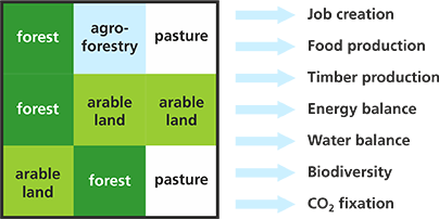
A land-use portfolio defines the set of ecosystem services for a catchment that must be balanced at economic, social, and ecological levels.

This is a complex process where different land-use forms mutually influence each other and where climate change adds even more complexity. Thus planning tools are needed that capture the complex interactions and distil the vast amounts of data into decision relevant information.

Ecosystem services

A planning tool must thus provide assistance in developing sustainable land-use scenarios to predict ecosystem service provision and confront them with changing climatic conditions in an if-then analysis.

Tool

Interactive map

Green Landscapes is a spatial decision support system (sDSS) for land-use optimisation.

It is designed as a free, easy to use, web-based solution that addresses holistic land-use management options for various climatic scenarios.

The software framework is a GIS integrated decision support system with model-based scenario simulation at its core. Land-use scenarios can be defined by rules and interactive map manipulation.

Integrated models

  • Hydrological model for water balance
  • Soil model
  • Model for forest growth (GLFor)
  • Knowledge-based management models for crops, greenland, sugar cane
  • Pre-defined climate scenarios
  • Digital elevation model

Analytical Hierarchical Process (AHP)

In a multi-criterial decision making process weights for each ecosystem service are derived based on an AHP. This allows a participatory prioritisation by stakeholders.

Reproducible results

All land-use scenarios are stored in a database including the intermediate results and model outputs. This way, scenarios can be easily compared and reproduced.

Web-based user interface

Green Landscapes is controlled by your browser. It can be used locally on your computer or as a centralized service.

Scenario-based planning

The Green Landscapes DSS can be applied to studies related to management of job creation, conservation areas, stream flow reduction, carbon accounting, environmental impact assessment, provable sustainability, production, and many other areas.

It allows policy-based prioritisation of ecosystem services and an objective comparison of scenarios. The differences between the scenarios are aggregated as charts but the complete output of the background models can also be explored in detail.

Land-use portfolio A compared to land-use portfolio B:

Scenario comparison

Use Cases

Green Landscapes is designed to be used by a broad range of users, including governmental bodies, NGOs, land owners, and regional planners.

Exemplary uses

Optimising ecosystem service provision for specific catchments

The Green Landscapes DSS supports holistic land-use planning to match the ecosystem services of a specific catchment. This way key ecosystem services such as carbon sequestration (REDD+), food security and biodiversity conservation as well as production of industrial goods and job creation can be balanced.

Climate change adaptation

The DSS supports land-use portfolio optimisation not only for current but also for future climatic conditions, so that adaptation planning for Climate Change is actively supported.

Environmental impact assessment (EIA)

In EIA’s effects of land use changes can be predicted by the Green Landscapes DSS and checked for their impacts on ecosystem service needs of a certain region. Since land owners and governmental bodies can make use of the system it acts as an objective negotiation tool between land owner and governmental bodies.

Certification

A land owner can prove sustainability for certification. Conservation issues are addressed directly in spatial planning collateral effects of production on nature (water, conservation, carbon, etc.) can be minimised.

Team

The Green Landscapes framework is developed by a multidisciplinary team of experts from Agriculture, Forestry, Conservation Ecology, Soil Science and Economics with strong links to experts in Socio-economics, Climatology, Remote Sensing, and Computer Sciences to face the transdisciplinary challenge of a holistic land-use planning.

Contact us

Green Landscapes Project
Department of Forest and Wood Science
Stellenbosch University
Tel: +27 21 808 3323

The financial assistance of the National Research Foundation (NRF) towards this research is hereby acknowledged. Opinions expressed and conclusions arrived at, are those of the author and not necessarily to attributed to the NRF.

Background images: Stefan Seifert, Nicholas A. Tonelli (Flickr), Damien du Toit (Flickr), theaucitron (Flickr)

Web design and programming: Erich Seifert